Marshall Plan Scholarship
About Organization
Objective
The primary objective of this project is to conduct a spatiotemporal analysis of nighttime crimes in Vienna, Austria, specifically focusing on the years from 2014 to 2018. The research will aim to address the following key objectives: 1) Investigate the correlation between nighttime lights (NTLs) and various types of nighttime crimes; 2) Analyze how different types of nighttime crimes relate to each other and identify areas where increased lighting may be necessary; 3) Examine the relationship between nighttime crimes and socioeconomic variables; and 4) Develop predictive models for nighttime crime hotspots using Convolutional Neural Network (CNN) algorithms
Tools & Technologies
ArcGIS Pro, Python
Project Details
This research was made possible through the funding provided by the Austrian Marshall Plan Foundation, an academic exchange program dedicated to offering scholarships and fellowships for academic exchange between Austria and the United States, with a specific emphasis on universities specializing in applied sciences and technical fields ('Fachhochschulen und Technische Universitäten'). I was fortunate to be a beneficiary of this scholarship, which allowed me to engage in research activities from May to August 2021 at Carinthia University of Applied Sciences in Austria. I received a scholarship amounting to €6,500, which significantly contributed to my research development.
This research project was conducted under the guidance of two supervisors, Dr. Michael Leitner from Louisiana State University and Dr. Gernot Paulus from Carinthia University of Applied Sciences. The project's primary focus was on conducting a spatiotemporal analysis of nighttime crimes that transpired in Vienna, Austria, covering the years from 2014 to 2018.
Methodologically, nighttime was defined as the period from 9 PM to 5 AM, considering variations in sunrise and sunset times and the operating hours of businesses. Crime data specific to Vienna were obtained from the Federal Criminal Police Office, with a focus on crimes that matched the FBI's Uniform Crime Reporting (UCR) Type I crimes for comparison with previous U.S.-based research.
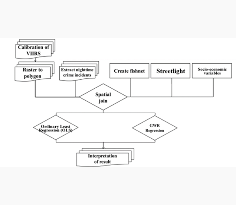
To analyze the correlation between nighttime crimes and nighttime lights (NTLs), data from the Visible Infrared Imaging Radiometer Suite (VIIRS) were utilized. VIIRS provided high-quality global data with a high spatial resolution and was considered more reliable than earlier systems like the Defense Meteorological Satellite Program Operational Line-Scan System (DMSP/OLS).
In addition to NTLs, various socioeconomic variables were assessed for their correlation with nighttime crime rates, including factors such as population, race, median family income, and education level. All relevant data were sourced from open data websites.
The research workflow was divided into raster dataset processing and vector dataset processing. Raster data processing involved processing VIIRS data and converting it to polygons for spatial analysis. For vector data, a grid-based approach was employed to ensure that modifiable areal unit problems (MAUP) were avoided, and grid cells were defined at a 750-meter cell size to match the VIIRS cell size.
The project's results included insights into the relationship between NTLs and nighttime crimes, including a negative correlation between NTLs and Type I crimes. Socioeconomic variables were also analyzed, providing a deeper understanding of their impact on crime rates. Furthermore, the application of CNN algorithms helped predict nighttime crime hotspots, aiding law enforcement in optimizing patrol routes and enhancing the potential use of NTL data in public safety..